Monday, October 14, 2013

Controlling the River: The Impact of Infrastructure on the Colorado River


In this post, I will explore the development of the Colorado River and how engineering and infrastructure has made the Colorado River the most developed river in the United States. I will also look at the effects of dams on rivers and how the environmental movement has shaped the current management of the Colorado River. 

The Colorado River is considered one of the most controlled rivers in the world. Today, the Colorado River serves water to roughly 36 million people for agricultural, industrial, and domestic needs and without the engineering of various infrastructure, this would not be possible. There are over 29 major dams along the Colorado River with hundreds of miles of canals to divert and deliver the water. 

Please click the link below to visit an interactive Colorado River map showing the various dams and diversions.

One of the most astonishing engineering manipulations of the Colorado River though, is the reservoir basins total storage capacity. Combining all of the reservoirs storage capability, an amount of four times the river’s annual flow can be stored along the river.  This fact has given the Colorado River the nickname, “America’s Nile.” 


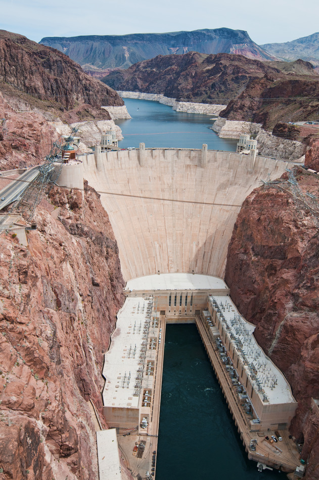
Hoover Dam: A Modern Wonder of the United States


View of the Salton Sea within the Imperial Valley
Photo courtesy of marlimillerphoto.com
In 1901, one of the first diversion projects on the Colorado River was completed, the Alamo Canal.  The Alamo Canal’s primary purpose was to bring Colorado River water to the Imperial Valley in southern California in order to irrigate this growing agricultural region. However, in 1905, a series of floods hit this region and washed out the floodgates of the Alamo Canal, allowing the entire Colorado River to flow into the Imperial Valley. It took two years and more than 3 million dollars to close the breech, but not before a 45-mile-long lake was created in the Imperial Valley, now known as the Salton Sea. After this catastrophe, it was realized that a more permanent solution was necessary if the Colorado River was going to be utilized.

Construction of Hoover Dam
Photo courtesy library.unlv.edu


Hoover Dam’s location was decided on Black Canyon, about 30 miles southeast of Las Vegas. Construction on the dam began in 1931 with the removal of 3.5 million tons of rock. (1 ton = 2,000 pounds) Over the course of four and a half yearssix of the nation’s largest construction companies and thousands of workers built Hoover Dam. The dam itself raises about 730 feet from its base (imagine a 70 story building) and is about 1,250 feet wide at its peak width across the top. Behind the dam sits Lake Mead, a 247 square-mile reservoir with a length of 112 miles across the largest stretch and the maximum water depth of 590 feet. The amount of water stored behind Hoover Dam would be enough to cover a state like Connecticut in 10 feet of water. 
Construction of Hoover Dam at night
Photo courtesy of library.unlv.edu


In 1928, after a series of investigations on the possibilities of damming the Colorado River, Congress passed the Boulder Canyon Act authorizing the construction of Boulder Canyon Dam, now Hoover Dam, and the All-American Canal to bring water to the Imperial Valley.


The construction of Hoover was a major step towards stabilizing the lower channel of the Colorado River, storing water for irrigation in times of drought, and providing much-needed flood control. Hoover Dam, for this reason, is one of the seven modern engineering wonders of the United States and changed the course of history for not only the Colorado River, but for the West.

Lake Mead behind Hoover Dam
Photo courtesy of wikimedia.org


Era of Dams


The Dust Bowl brought public approval for water projects
Photo courtesy of http://midatlanticgardening.com
Following the construction of Hoover Dam, an era of dam building began. Water developing agencies across the nation, particularly in the West, launched a “forty-year binge” of dam building. Until the mid 1970’s, around 1,000 large dams per year were under construction throughout the world, 500 of these being built in the United States. A large dam is defined as one higher than 15 meters (taller than an average 4 story building). The Great Depression and subsequent New Deal politics initiated the authorization of these water development projects, since such public works projects would stimulate the economy. Not only that, but the 1930’s mid-continent drought, known as the Dust Bowl, helped generate public support for water development projects.

A stretch of the Colorado River Aqueduct
Photo courtesy of lbwater.org
During this period, numerous projects occurred along the Colorado River. Projects not only to store water, but also to deliver water, for flood control, and to generate electricity. The Lower Basin states looked to develop the Colorado River for municipal purposes in this time of growing urban centers. Specifically, the Colorado River Aqueduct, completed in 1941, delivers water 250 miles to Los Angeles and due to the population growth in Las Vegas Valley from Hoover Dam, Las Vegas tapped a pipeline from Lake Mead in 1937. Colorado leads the Upper Basin states in water development projects, the most notable project being the Roberts Tunnel, which diverts water from the Colorado River to Denver.

Construction of the Roberts Tunnel to bring
Colorado River water to Denver, Colorado
Photo courtesy of Denver Water

Without the addition of surface water storage in the Upper Basin, there was no guarantee that the Upper Basin states would be able to use the full amount of water given to them by the compact and thus many reservoirs were built including the Lake Powell, Flaming Gorge, and Navajo. Projects like these were occurring around each bend on the river. In the growing West, water meant a future for urban cities to expand. However, in the 1980’s a new era began that closed the door on major dam building, the environmental movement.


Environmental Movement Shifts Infrastructure Future


The environmental movement began as a desire to manage the natural resources of the land and protect it from over-industrialization. Although the environmental movement began much earlier, the era of large dam building came to a close in 1969 with the formation of the National Environmental Protection Act (NEPA). NEPA set policies that directed all branches of the federal government to protect the environment. Any action planned by a federal agency has to be preceded by an Environmental Impact Statement (EIS), which details the effects of the proposed action upon the environment. The Act also requires an annual report on environmental quality from the President.

Various considerations are needed in the NEPA decision-making process
Photo courtesy of projectpermits.com
NEPA put a halt on large dam projects for a number of reasons. Specifically along the Colorado River, large dams such as Hoover Dam and Glen Canyon Dam have numerous environmental consequences that include direct impacts to the biological, chemical, and physical properties of the river and riparian (banks of the river) environments. Below is a list of some, not all, of the environmental impacts of large dams on the Colorado River.

  • Dam walls block fish migrations, which in some cases completely separate spawning habitats from rearing habitats
  • Dam walls trap sediments, which are critical for maintaining physical processes and habitats downstream of the dam
  • Transformation upstream of the dam from a free-flowing river ecosystem to an artificial flow-restricted reservoir habitat impact aquatic and riparian life, sometimes destroying the system completely
  • Changes in temperature, chemical composition, dissolved oxygen levels and the physical properties of a reservoir are often not suitable to the aquatic plants and animals that evolved with a given river system

Diagram of components on a free-flowing river and a dammed river
Photo courtesy of vtwaterquality.org


For these reasons, and many others, environmental groups have altered the management of the Colorado River by stepping in when new actions are proposed to alter the state of the river. Today, infrastructure managers and engineers are placed with the challenge of finding sustainable ways to supply water to the growing West, while also maintaining or bettering the conditions along the river. Unlike in the mid 1900s where the solution to water problems along the river was to build more, today the solution is not in constructing more projects, but rather to manage the current infrastructure in a more sustainable way.


A thriving and healthy Colorado River ecosystem is one
of the many environmental movement aspirations
Photo courtesy of secure2.edf.org 


In my next post, I will investigate the current issues surrounding both endangered species and invasive species along the Colorado River and what is being done in regards to these issues.

Wednesday, October 9, 2013

Law of the River: Policies Navigating the Colorado River


In this post, I will attempt to layout the very basics of the laws regulating the Colorado River starting with the Colorado River Compact of 1922 and touching on various components of the Law of the River.

How Policy has Shaped the Colorado River


The 100th Meridian is clearly defined by the yellow line down
the middle of the U.S. West of the 100th Meridian, precipitation
is less and highly varied.
Photo courtesy of
http://grist.files.wordpress.com/2008/07/precip.jpg
In 19th century America, the popular notion of Manifest Destiny, a term for American expansion and the belief that the United States not only could, but was destined to stretch from coast to coast, drove many Americans to settle in the western parts of the United States. As early settlers began to inhabit western America though, it became apparent that there was a great difference between the amount of water on the East versus the West. In the West, there is not only less water, but the water that does appear, in the form of rain or snow, is highly varied. This crucial fact laid the basis to western water law.

Basis of Eastern and Western Water Laws


In the East, water law is defined by riparian rights. Simply put, riparian water law states that all landowners whose property is adjoining to a body of water have the right to make reasonable use of it. In the West, far less bodies of water exist and thus a form of water law called prior appropriations, or a combination of riparian and prior appropriations exists. A simplified way to explain prior appropriations is by the common phrase, "first in time, first in right". 

Photo courtesy of ww.oregon.gov

An appropriation is made when an individual physically takes water from a stream and places that water to some type of beneficial use. The first person to appropriate water and apply that water to use has the first right to use that water within a particular stream system. This person (after receiving a court decree verifying their priority status) then becomes the senior water right holder on the stream, and that water right must be satisfied before any other water rights can be fulfilled.”


A reasonableand beneficial use, as defined by the prior appropriations includes “municipal and industrial uses, irrigation, hydroelectric generation, and livestock watering. More recently, the concept has been broadened to include recreational use, fish and wildlife protection, and enhancement and aesthetic enjoyment”. Water rights, unique to prior appropriation law, are unconnected to land ownership, and can be sold or mortgaged like other property, whereas water rights under riparian law cannot be sold or mortgaged.


Overview of the Colorado River Basin
Photo courtesy of Professor R. Balaji


Colorado River Compact of 1922


Water law along the Colorado River is complex due to its transboundary nature and high demands for the water, nestled with the arid climate it resides in. Since each state administers water laws individually, the Colorado River Compact of 1922 was formed to initiate cooperation along the river and to allocate the water as to not over use and dry up the river.


The Colorado River Compact of 1922 divided the basin into the Upper and Lower Basins and was written so that the waters of the Colorado River would be divided on a 50-50 basis between the Upper and Lower basins. Each basin is allotted 7.5 million acre-feet of water in perpetuity, or indefinitely. To give a perspective of how much water 7.5 million acre-feet is, one acre-foot supplies water for an average of 2 households for one year.


Photo courtesy of http://greatecology.com


Law of the River


Although the compact attempted to look at the future water needs of the Colorado River Basin, the signers could not foresee the immense urban growth, the movement towards protecting the natural environment, or the implications of climate change in the 21st century. With the Colorado River Compact of 1922 serving as the foundation, the Colorado River is managed and operated under numerous compacts, federal laws, court decisions and decrees, contracts, and regulatory guidelines collectively known as the "Law of the River."  The Law of the River is very complex so the rest of this blog will touch base on the key aspects of the Law of the River.


Hoover Dam and Power Plant
Photo courtesy of http://lasvegastours.onboardtours.com

Boulder Canyon Project Act (1928)


Reliably providing both the Upper and Lower basins with 7.5 million acre-feet of water annually in such a varying water system would not be possible without storage infrastructure, such as reservoirs. The main purpose of the Boulder Canyon Project Act was to build the first infrastructures on the river to aid in the stability and reliability of water supply along the river. 
The Boulder Canyon Project Act authorized the construction of,
  • Hoover Dam
  • Power Plant at Hoover Dam
  • All-American Canal


Mexican Water Treaty (1944)


The Mexican Water Treaty allocated to Mexico 1.5 million acre-feet of water annually. The allocation was to be increased in years of surplus to 1.7 million acre-feet and reduced proportionately during years of extraordinary drought. The Treaty dealt with quantity and was silent on the quality of water to be delivered which was debated in 1972 with the establishment of Minute 242 and the Colorado River Basin Salinity Control Act of 1974.


Figure 1: Breakdown of allocations by basin
Photo courtesy of http://www.riversimulator.org

Upper Colorado River Compact (1948) and Arizona v. California (1964), U.S. Supreme Court Decree


The Colorado River Compact did not apportion a specific amount of water to each state within the basins. In 1948, through the Upper Colorado River Basin Compact, the Upper Basin agreed upon annually allotting each of the Upper Basin states a percentage of the 7.5 million acre-feet of water. The Lower Basin, on the other hand, could not reach an agreement on the allotment of water to each state so in 1964, the U.S. Supreme Court decided on allocating the 7.5 million acre-feet of water in a similar manner as the Upper Basin, by percentages. Please refer to Figures 1 and 2 to see the breakdown of the Upper and Lower Basin allotments.

Figure 2: Breakdown of total Colorado River water allocation
Photo courtesy of http://www.h2ouniversity.org

Colorado River Basin Project Act (1968)


Under the Colorado River Basin Project Act, the authorization of the Central Arizona Project and other water development projects in the Upper Basin were made. The Central Arizona Project allows the major part of Arizona’s Colorado River allotment to be sent to the south-central part of the state. Overall, this Act took into account the changing future and the need for more efficient storage structures, especially for times of drought, as well as coordinating long-range operation of the reservoirs along the Colorado River. Lastly, this Act undertook programs for water salvage and groundwater recovery along the river.

A stretch of the Central Arizona Project
Photo courtesy of http://arizonaexperience.org

Minute 242 (1973) and Colorado River Basin Salinity Control Act (1974)


Under the Mexican Treaty in 1944, only the quantity of water delivered to Mexico was addressed and not the quality and so, the water entering Mexico was of very low quality. In 1973, Minute 242 was established to set a standard on the quality of water entering Mexico and in order to achieve this standard, in 1974 through the Salinity Control Act, multiple desalination plants and salinity control units were set up along various parts of the Colorado River.

Yuma desalination plant
Photo courtesy of http://www.azwater.gov


Although this is a simple synopsis of the key components of the Law of the River, it is important to keep in mind that the combination of these complex laws are ever-evolving to the changing times. More notably though, is how well the Law of the River stands as a model for managing complex water basins throughout the world by addressing not only the needs of the players involved, but also environmental aspects as well. 

Next time, I will investigate the various infrastructure along the Colorado River and how “taming” the river has allowed for civilization to thrive in the arid and drought stricken region of the Southwest.