In this post, I will attempt to layout the very basics of
the laws regulating the Colorado River starting with the Colorado River Compact
of 1922 and touching on various components of the Law of the River.
How Policy has Shaped the Colorado River
 |
| The 100th Meridian is clearly defined by the yellow line down the middle of the U.S. West of the 100th Meridian, precipitation is less and highly varied. Photo courtesy of http://grist.files.wordpress.com/2008/07/precip.jpg |
Basis of Eastern and Western Water Laws
In the East, water law is defined by riparian rights. Simply put, riparian water law states that all landowners whose property is adjoining to a body of water have the right to make reasonable use of it. In the West, far less bodies of water exist and thus a form of water law called prior appropriations, or a combination of riparian and prior appropriations exists. A simplified way to explain prior appropriations is by the common phrase, "first in time, first in right".
 |
| Photo courtesy of ww.oregon.gov |
“An appropriation is made when an individual physically takes water from a stream and places that water to some type of beneficial use. The first person to appropriate water and apply that water to use has the first right to use that water within a particular stream system. This person (after receiving a court decree verifying their priority status) then becomes the senior water right holder on the stream, and that water right must be satisfied before any other water rights can be fulfilled.”
A reasonableand beneficial use, as defined by the prior appropriations includes “municipal and industrial uses, irrigation, hydroelectric generation, and livestock watering. More recently, the concept has been broadened to include recreational use, fish and wildlife protection, and enhancement and aesthetic enjoyment”. Water rights, unique to prior appropriation law, are unconnected to land ownership, and can be sold or mortgaged like other property, whereas water rights under riparian law cannot be sold or mortgaged.
 |
| Overview of the Colorado River Basin Photo courtesy of Professor R. Balaji |
Colorado River Compact of 1922
Water law along the Colorado River is complex due to its transboundary nature and high demands for the water, nestled with the arid climate it resides in. Since each state administers water laws individually, the Colorado River Compact of 1922 was formed to initiate cooperation along the river and to allocate the water as to not over use and dry up the river.
The Colorado River Compact of 1922 divided the basin into the Upper and Lower Basins and was written so that the waters of the Colorado River would be divided on a 50-50 basis between the Upper and Lower basins. Each basin is allotted 7.5 million acre-feet of water in perpetuity, or indefinitely. To give a perspective of how much water 7.5 million acre-feet is, one acre-foot supplies water for an average of 2 households for one year.
 |
| Photo courtesy of http://greatecology.com |
Law of the River
Although the compact attempted to look at the future water needs of the Colorado River Basin, the signers could not foresee the immense urban growth, the movement towards protecting the natural environment, or the implications of climate change in the 21st century. With the Colorado River Compact of 1922 serving as the foundation, the Colorado River is managed and operated under numerous compacts, federal laws, court decisions and decrees, contracts, and regulatory guidelines collectively known as the "Law of the River." The Law of the River is very complex so the rest of this blog will touch base on the key aspects of the Law of the River.
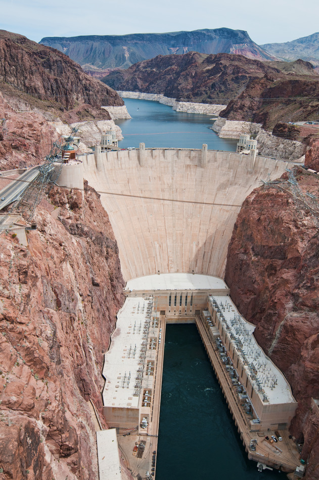 |
| Hoover Dam and Power Plant Photo courtesy of http://lasvegastours.onboardtours.com |
Boulder Canyon Project Act (1928)
Reliably providing both the Upper and Lower basins with 7.5 million acre-feet of water annually in such a varying water system would not be possible without storage infrastructure, such as reservoirs. The main purpose of the Boulder Canyon Project Act was to build the first infrastructures on the river to aid in the stability and reliability of water supply along the river.
The Boulder Canyon
Project Act authorized the construction of,
- Hoover Dam
- Power Plant at Hoover Dam
- All-American Canal
Mexican Water Treaty (1944)
The Mexican Water Treaty allocated to Mexico 1.5 million acre-feet of water annually. The allocation was to be increased in years of surplus to 1.7 million acre-feet and reduced proportionately during years of extraordinary drought. The Treaty dealt with quantity and was silent on the quality of water to be delivered which was debated in 1972 with the establishment of Minute 242 and the Colorado River Basin Salinity Control Act of 1974.
 |
| Figure 1: Breakdown of allocations by basin Photo courtesy of http://www.riversimulator.org |
Upper Colorado River Compact (1948) and Arizona v. California (1964), U.S. Supreme Court Decree
The Colorado River Compact did not apportion a specific amount of water to each state within the basins. In 1948, through the Upper Colorado River Basin Compact, the Upper Basin agreed upon annually allotting each of the Upper Basin states a percentage of the 7.5 million acre-feet of water. The Lower Basin, on the other hand, could not reach an agreement on the allotment of water to each state so in 1964, the U.S. Supreme Court decided on allocating the 7.5 million acre-feet of water in a similar manner as the Upper Basin, by percentages. Please refer to Figures 1 and 2 to see the breakdown of the Upper and Lower Basin allotments.
 |
| Figure 2: Breakdown of total Colorado River water allocation Photo courtesy of http://www.h2ouniversity.org |
Colorado River Basin Project Act (1968)
Under the Colorado River Basin Project Act, the authorization of the Central Arizona Project and other water development projects in the Upper Basin were made. The Central Arizona Project allows the major part of Arizona’s Colorado River allotment to be sent to the south-central part of the state. Overall, this Act took into account the changing future and the need for more efficient storage structures, especially for times of drought, as well as coordinating long-range operation of the reservoirs along the Colorado River. Lastly, this Act undertook programs for water salvage and groundwater recovery along the river.
 |
| A stretch of the Central Arizona Project Photo courtesy of http://arizonaexperience.org |
Minute 242 (1973) and Colorado River Basin Salinity Control Act (1974)
Under the Mexican Treaty in 1944, only the quantity of water delivered to Mexico was addressed and not the quality and so, the water entering Mexico was of very low quality. In 1973, Minute 242 was established to set a standard on the quality of water entering Mexico and in order to achieve this standard, in 1974 through the Salinity Control Act, multiple desalination plants and salinity control units were set up along various parts of the Colorado River.
 |
| Yuma desalination plant Photo courtesy of http://www.azwater.gov |
Although this is a simple synopsis of the
key components of the Law of the River, it is important to keep in mind that
the combination of these complex laws are ever-evolving to the changing times.
More notably though, is how well the Law of the River stands as a model for
managing complex water basins throughout the world by addressing not only the
needs of the players involved, but also environmental aspects as well.
Next time, I will investigate the various
infrastructure along the Colorado River and how “taming” the river has allowed
for civilization to thrive in the arid and drought stricken region of the
Southwest.
No comments:
Post a Comment